


Hunting Points: GPS Hunt Map
4.220.00 Reviews
App Specs
- Version
- 1.4.1
- Updated On
- License
- Free
- Downloads
- 10,000+
- Developer
- Fishing Points d.o.o.
- Categories
- Maps & Navigation
- Platform
- Android
Screenshots
 Analysis by AppCompare
On a hunting trip, remembering where a trail bends or a promising spot sits can be as useful as finding your way back to the car. I like the idea of keeping those details in one place, especially when the day involves moving between locations and coordinating with other people. Hunting Points: GPS Hunt Map is aimed at that kind of practical outdoor planning, rather than being a general-purpose navigation app with hunting use added as an afterthought.
What to expect from the map
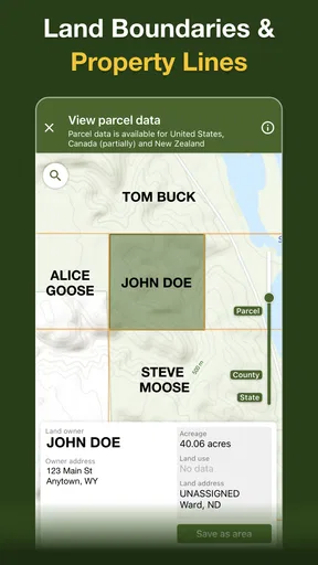
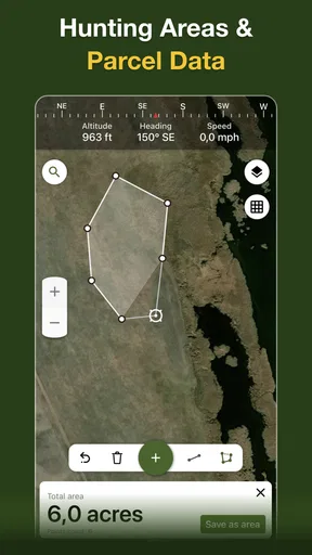
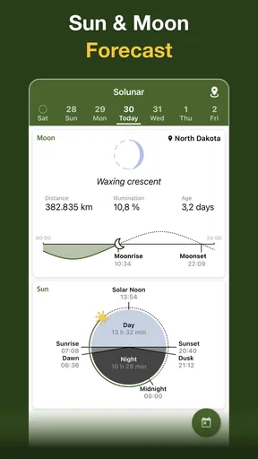
The app’s central appeal is having hunting-related information alongside a GPS map: property lines, landowner information, offline maps and deer hunting times are among the tools it promotes. For a hunter checking an unfamiliar area, those details can help answer different questions in one workflow: where am I, what land am I looking at, and when might hunting conditions be suitable? That focus is what sets it apart from an ordinary map app, which may show roads and terrain but is not designed around hunting decisions.
I would still treat any map information as a planning aid, not permission to enter land. Property boundaries and ownership details are useful prompts for checking a location, but responsible hunters should confirm access rules and local requirements before crossing a boundary. A practical habit is to review the route and relevant land details before setting out, rather than trying to interpret everything while moving through unfamiliar terrain.
Planning before you lose signal
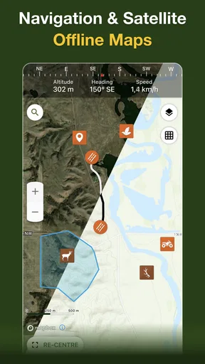
Offline GPS maps are particularly relevant when a hunt takes you beyond dependable mobile coverage. The useful workflow is to prepare the area you expect to visit while you have a connection, then check that the map is available before leaving. Offline navigation can reduce dependence on a signal, but it does not make a phone infallible: battery, GPS reception, and knowing how to get back still matter. I’d keep a charged phone and a backup navigation plan for remote outings.
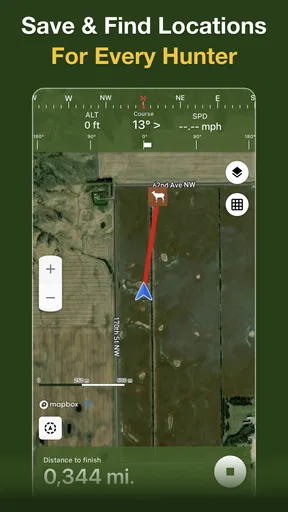
Saved waypoints can also make a trip more organized. Marking a parking spot, a trail junction, or a place to revisit gives you a record that is more useful than relying on memory at the end of a long day. If you add notes or photos, keep them specific: a short reminder about the approach or what you noticed there is easier to use later than a vague label. That small bit of discipline can turn a collection of pins into a genuinely helpful field log.
Who will get the most from it
I’d consider this app most useful for hunters who regularly visit changing areas, need to think about property boundaries, or want a map that remains useful when cell service drops. It may also suit a small group that plans a day together and wants to communicate about locations. For someone who only needs turn-by-turn directions on paved roads, a standard navigation app is likely simpler. And if you prefer paper maps or already have a trusted mapping setup, this is worth considering only if its hunting-specific information fills a real gap.
A realistic use case is planning a weekend visit to a new area. Before driving out, you can inspect the map, note a likely access route, and prepare for offline use. Once there, you can save a waypoint for the vehicle and mark a location you may want to revisit. If you are sharing information with a friend, be deliberate about what you send: a private hunting spot is not something everyone will want to distribute broadly. The value is not just in placing a pin, but in deciding what information belongs in your personal record and what is appropriate to share.
Worth Reading Before You Choose

Flipboard Shows What News Apps Must Do Beyond the Feed

Switching to Android Auto Means Rethinking Your Driving Routine

Google Calendar Makes a Crowded Week Easier to Manage

Ludo King Makes the Most of the Minutes Between Plans

Baby Panda World Brings Quick Play to Modern Phones, but Its Game Library Feels Busy

ESPN’s Live Game View Makes Following Close Games Easier
First Impressions and Key Features
As soon as I launched Hunting Points, I was greeted with a clean and intuitive interface. It's got that rugged outdoor vibe without being too much in your face, which I appreciate. The app's main function is to serve as a GPS map designed specifically for hunting. But trust me, it offers so much more than just location tracking.
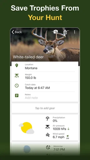
One of the first features that caught my eye was the ability to mark waypoints. You can easily pinpoint your favorite hunting spots, set up blind locations, and even mark animal sightings. The best part? You can attach photos and notes to each point. It's like having a digital hunting diary at your fingertips.
Weather and Wind Forecasts
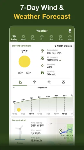
Now, we all know that weather can make or break a hunting trip. This app has a built-in weather forecast feature that provides detailed information on wind speed and direction. It’s not just about knowing if you need a raincoat; it's about planning your approach strategy based on the wind's behavior. Pretty nifty, right?
Sharing and Community Features
Another standout feature is the ability to share your hunting spots with friends. Whether you’re planning a group hunt or just want to brag about your new secret spot, you can easily share your locations. Plus, there's a feature to keep certain spots private, you know, just in case you don’t want everyone crashing your hunting party.
There's also a community aspect to the app. You can connect with fellow hunters, exchange tips, and even get advice on the best gear. It’s like having a mini social network right in your pocket.
Speed, stability, and field use
For an app used outdoors, the important question is not simply whether screens open quickly at home; it is whether the information you need is ready when you are away from a strong connection. I’d prepare maps and review saved locations before heading out instead of assuming every detail will load instantly in the field. GPS positioning and map loading can depend on the phone, surroundings, and network conditions, so I wouldn’t promise identical responsiveness on every device or in every location.
Heavy use is where planning pays off. Switching between a map, saved points, photos, notes, and weather information can be more demanding than checking a single location. I’d keep the screen brightness sensible, close other apps I do not need, and carry a power bank on a long outing. Those are good habits for any phone-based navigation tool, not a special fix for this one. They also reduce the chance that a useful map becomes inaccessible late in the day because the phone has run low.
Reliability means more than the app staying open. A waypoint is only helpful if you can recognize it later, so I’d use clear names and add a brief note when the context matters. For instance, label a point as a trail junction or vehicle location rather than leaving a set of indistinguishable markers. If something appears out of place, check your position and map view before acting on it. In unfamiliar terrain, a digital tool should support good judgement, not replace it.
Device fit and practical trade-offs
This is a free Maps & Navigation app from Fishing Points d.o.o., with in-app purchases priced from $5.99 to $29.99 per item. Its average rating is 4.3 from 148 ratings, with 18 written reviews, and it has 10K+ installs. It was released on Jun 21, 2023; version 1.4.1 requires Android 6.0 or later, and its content rating is Everyone. These details make it accessible to a broad range of users, though the purchase options mean I’d check which tools are included before building a routine around a feature I expect to use often.
Compared with a general map, the app’s hunting focus is its strongest reason to try it; a standard navigation tool may be preferable for driving directions, transit, or everyday errands. Compared with relying only on a paper map, digital waypoints are easier to annotate and revisit, but they depend on a working device and battery. I’d use the option that fits the outing, and for remote trips I would not make a phone the only way to navigate.
The app is also not a substitute for checking local hunting rules or getting clear permission to access land. Landowner and boundary information can help with research, but users should verify important access decisions through appropriate local sources. That is especially important when a boundary is unclear or a route passes near private property. A little checking in advance is a better trade-off than discovering a problem after arriving.
User Experience and Performance
Let's talk about how smoothly this app runs. I’ve used it on both Android and iOS, and the performance was consistently reliable. The GPS tracking is spot on, and I never experienced any lag or glitches. The app also works offline, which is a huge plus when you’re deep in the wilderness with no cell signal.
Battery life can be a concern with GPS apps, but I found that Hunting Points is surprisingly gentle on the battery. A full day of tracking barely made a dent, which means more time focusing on the hunt and less time worrying about your phone dying.
Who should choose another approach
If you need a dedicated vehicle navigator, a detailed route planner for activities beyond hunting, or a map source you can rely on without checking its coverage and saved areas first, this may not be the right single tool. Likewise, someone who does not want to manage digital notes, device charge, or possible in-app purchases may be happier with a simpler map setup. I’d try it on a familiar outing before depending on it for a remote trip; that gives you a chance to learn the interface and decide whether its hunting details suit your habits.
Final Thoughts
So, is Hunting Points: GPS Hunt Map worth downloading? Absolutely. Whether you’re a seasoned hunter or just getting started, this app provides a comprehensive set of tools that can elevate your hunting experience. From accurate GPS tracking to community features and weather forecasts, it covers all bases.
Sure, it might not replace the thrill of the chase or the satisfaction of a successful hunt, but it certainly makes planning and executing your trips a whole lot easier. So go ahead, give it a shot, and happy hunting!
Pros
- Detailed GPS mapping for accurate navigation.
- Offline maps available for remote areas.
- Customizable waypoints for tracking routes.
- Real-time weather updates for planning trips.
- Intuitive interface for easy use.
Cons
- Limited social features for community sharing.
- Requires frequent updates for new regions.
- Battery consumption can be high.
- Subscription needed for full features.
- May have occasional GPS signal loss.
FAQs for Hunting Points: GPS Hunt Map
What is Hunting Points: GPS Hunt Map used for?
Hunting Points: GPS Hunt Map is designed to assist hunters in navigating outdoor environments with ease. It provides GPS maps, tracking features, and hunting locations to enhance your hunting experience. With offline capabilities, it ensures that you can access vital information even in remote areas without cellular service.
Does Hunting Points: GPS Hunt Map work offline?
Yes, Hunting Points: GPS Hunt Map offers offline functionality, allowing users to download maps for use in areas without internet access. This feature is particularly useful for hunters who venture into remote locations, ensuring they have continuous access to maps and location services without relying on a cellular connection.
How accurate is the GPS tracking in the app?
The GPS tracking in Hunting Points is highly accurate, leveraging advanced satellite technology to provide precise location data. This ensures that hunters can reliably track their movements and mark important waypoints, making it easier to navigate and plan hunting trips effectively. However, accuracy may vary slightly depending on the device and environmental conditions.
Is Hunting Points: GPS Hunt Map suitable for beginners?
Yes, Hunting Points is user-friendly and suitable for both beginners and experienced hunters. The intuitive interface and easy-to-understand features make it accessible to those new to hunting, while the advanced options offer depth for seasoned users. Tutorials and guides are available to help new users get started quickly.
What are the key features of Hunting Points: GPS Hunt Map?
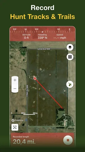
Key features of Hunting Points include offline maps, GPS tracking, hunting location markers, and detailed weather forecasts. The app also allows users to record hunting sessions and share data with friends. These features are designed to enhance safety and efficiency, providing a comprehensive tool for planning and executing successful hunting trips.


